For more photos from this hike click this link: http://smu.gs/164122E
Got back a little while ago from what turned out to be a 9 mile trek through the Santa Cruz Mountains at the Skyline Ridge OSP. This is the first time I have hiked there and I was quite impressed. I have to admit I didn't intend on doing 9 miles when I started but I guess my math was a little fuzzy when adding up the distances of the trail parts. Skyline Ridge is located in the Santa Cruz Mts on Highway 35 a few miles north of the Highway 9 junction (just before Russian Ridge OSP).
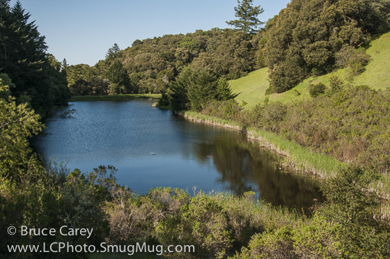
I began my hike with a loop around Horseshoe Lake (an aptly named "U" shaped lake. What a beautiful spot! If you follow the complete loop you pretty much see the lake from just about every angle possible. The trail ranges from being right at lake level to several hundred feet above so there is plenty of variety. While there was not a lot of wildlife there today but I imagine, like most lakes, it can probably be quite lively at times. The walk around the lake is short, maybe a mile or so and not at all difficult so there are no excuses for not getting out and seeing this gem (the first part is even wheelchair friendly). At the interior bottom of the y
"U" nestled in the rewoods about 100 feet up frokm the lake the trail passes two picnic tables that I've got to say are probably one of the best spots for a picnic I've seen in a while!
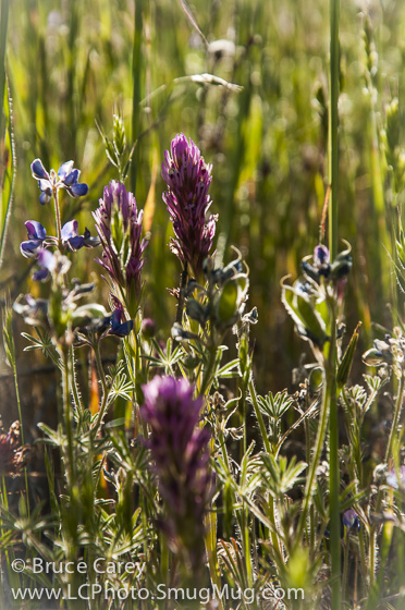
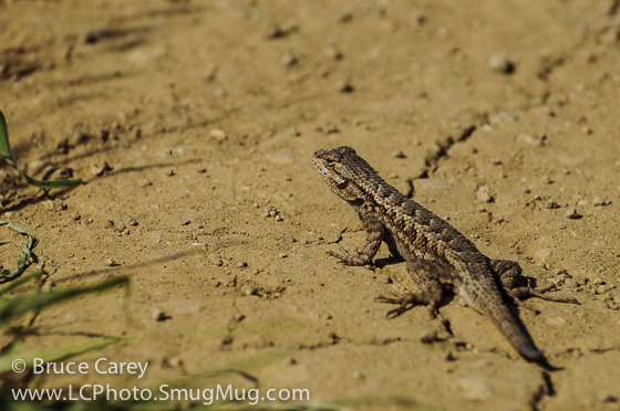
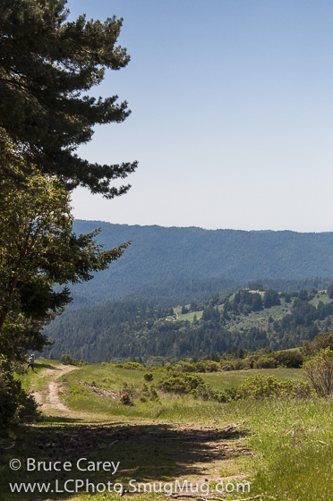
I continued from the lake and did a loop that started on the Ridge Trail (strangely called the Iweia (?) trail on the signs on the trail which after a brief moderate to steep incline leveled off and followed along the ridge providing great views of both the redwood filled valley and hills as well as vies of the fogged in coast. The mostly sunny section trail was a playground for lizards.
The ridge Trail eventually lands you at the Aline Pond at Russian Ridge OSP. From here you can loop back around on another trail (un-named on the map and I don't remember if it had a name or not but the signage is pretty specific about pointing you back the the Skyline Ridge parking lot). However I had been intrigued by a nearby trail I saw on the map called the Old Page Mill Trail and decided to check that out.
The Old Page Mill Trail is, I'm guessing, just what it says. an old extension of Page Mill Road. It starts as a somewhat maintained paved road for about .2 miles but after passing the Park Rangers residence the road has not been maintained and the paving is rapidly covered over with dirt and growing plants. This trail is not well maintained so I would only suggest taking it if you are comfortable with climbing over downed branches and tress crossing the trail. The width of the road is always present but in places the plant growth narrows the trail to a single track.
I will say this it is well worth the effort. For the full 1.5 mile mostly slow descent into the valley you alternate between dense redwood and oak/bayberry forests. At times the only sound is that of the breeze rushing through the needles of the redwoods. The trail ends at d stream and it's a great place to take a break. Since it's not a loop you head back up the trail. It's not a steep climb but it is more or less 1.5 miles of steady up.
On reaching Alpine Pond I was pretty beat and hoping for some level ground. Unfortunately the level only lasted a short while and I had to endure some pretty steep uphill climbing throuhg more redwoods and open grasslands before descending back to the parking lot.
I have to admit this was a pretty tough hike. I intend on going back as the scenery was great. However I will probably not include the Old Page Mill Trail on this hike. It can be more reasonably accessed from Russian Ridge OSP.
bc
Got back a little while ago from what turned out to be a 9 mile trek through the Santa Cruz Mountains at the Skyline Ridge OSP. This is the first time I have hiked there and I was quite impressed. I have to admit I didn't intend on doing 9 miles when I started but I guess my math was a little fuzzy when adding up the distances of the trail parts. Skyline Ridge is located in the Santa Cruz Mts on Highway 35 a few miles north of the Highway 9 junction (just before Russian Ridge OSP).
I began my hike with a loop around Horseshoe Lake (an aptly named "U" shaped lake. What a beautiful spot! If you follow the complete loop you pretty much see the lake from just about every angle possible. The trail ranges from being right at lake level to several hundred feet above so there is plenty of variety. While there was not a lot of wildlife there today but I imagine, like most lakes, it can probably be quite lively at times. The walk around the lake is short, maybe a mile or so and not at all difficult so there are no excuses for not getting out and seeing this gem (the first part is even wheelchair friendly). At the interior bottom of the y
"U" nestled in the rewoods about 100 feet up frokm the lake the trail passes two picnic tables that I've got to say are probably one of the best spots for a picnic I've seen in a while!
I continued from the lake and did a loop that started on the Ridge Trail (strangely called the Iweia (?) trail on the signs on the trail which after a brief moderate to steep incline leveled off and followed along the ridge providing great views of both the redwood filled valley and hills as well as vies of the fogged in coast. The mostly sunny section trail was a playground for lizards.
The ridge Trail eventually lands you at the Aline Pond at Russian Ridge OSP. From here you can loop back around on another trail (un-named on the map and I don't remember if it had a name or not but the signage is pretty specific about pointing you back the the Skyline Ridge parking lot). However I had been intrigued by a nearby trail I saw on the map called the Old Page Mill Trail and decided to check that out.
The Old Page Mill Trail is, I'm guessing, just what it says. an old extension of Page Mill Road. It starts as a somewhat maintained paved road for about .2 miles but after passing the Park Rangers residence the road has not been maintained and the paving is rapidly covered over with dirt and growing plants. This trail is not well maintained so I would only suggest taking it if you are comfortable with climbing over downed branches and tress crossing the trail. The width of the road is always present but in places the plant growth narrows the trail to a single track.
I will say this it is well worth the effort. For the full 1.5 mile mostly slow descent into the valley you alternate between dense redwood and oak/bayberry forests. At times the only sound is that of the breeze rushing through the needles of the redwoods. The trail ends at d stream and it's a great place to take a break. Since it's not a loop you head back up the trail. It's not a steep climb but it is more or less 1.5 miles of steady up.
On reaching Alpine Pond I was pretty beat and hoping for some level ground. Unfortunately the level only lasted a short while and I had to endure some pretty steep uphill climbing throuhg more redwoods and open grasslands before descending back to the parking lot.
I have to admit this was a pretty tough hike. I intend on going back as the scenery was great. However I will probably not include the Old Page Mill Trail on this hike. It can be more reasonably accessed from Russian Ridge OSP.
bc
 RSS Feed
